Sector(s)
Team Members
Project Team
Lead development and design consulting: PROGRESSIVE digital
Client and editorial team: VisLab, Leibniz Institute for Regional Geography (IfL)
Atlas concept and visualizations: Mela Žuljević, Iaroslav Boretskii
Visualization editor: Jana Moser
Visit the site
Visit the siteOrganizations Involved
Community contributions
- PROGRESSIVE digital is a Drupal Association Bronze Supporting Partner
- Contributed to the Drupal ecosystem through development of specialized geospatial and scrollytelling integrations on Drupal 11
- Active knowledge sharing around accessibility-first editorial workflows in academic and public sector contexts
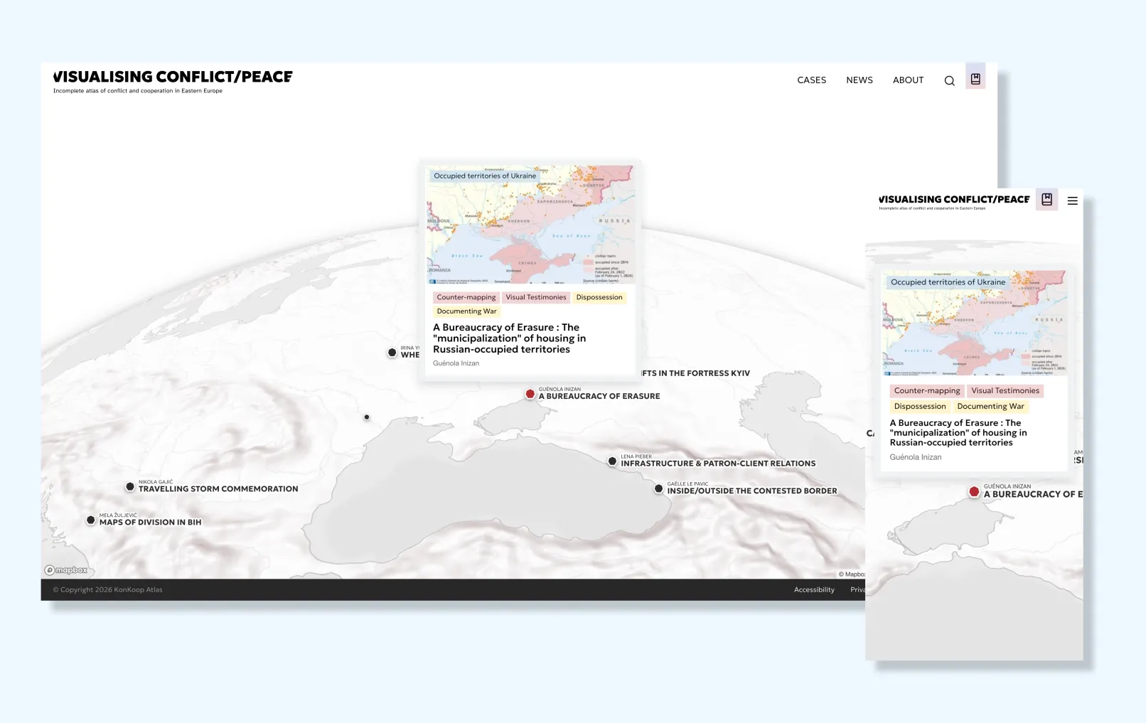
Visualising Conflict/Peace is a collaborative digital atlas produced by the VisLab at the Leibniz Institute for Regional Geography (IfL) as part of the KonKoop (Conflict and Cooperation in Eastern Europe) research network. Launched in 2026, it brings together researchers, cartographers, artists, and field experts to publish geospatial case studies on conflict and peace dynamics across Eastern Europe, the Western Balkans, the South Caucasus, and Central Asia. PROGRESSIVE digital provided web design and development for the platform, working closely with the IfL editorial team on UI and UX consulting throughout the project.
About the project
Goals
The atlas was conceived to address a gap in peace and conflict research: the absence of a reflexive, multiperspective digital publication format capable of hosting complex geospatial narratives without reducing them to simple truths or resolutions. The IfL needed a platform that could grow iteratively as new cases were contributed, support interdisciplinary workflows involving cartographers, researchers, and visual designers, and remain accessible to both academic specialists and a broader public interested in conflict and cooperation in Eastern Europe.
Challenges
The project posed several significant challenges. The content itself is inherently complex — cases involve sensitive topics such as war, trauma, displacement, and contested borders, requiring careful information architecture that neither sensationalizes nor oversimplifies. Each case needed to surface multiple, often conflicting perspectives through embedded reflections, interactive map visualizations, and layered navigation. At the same time, the platform had to accommodate a continuously evolving content structure: new cases, new visual methods, and new thematic categories are added over time, making extensibility a core technical requirement. Integrating diverse visualization formats — from static cartography to interactive Leaflet and Mapbox GL JS maps with scrollytelling elements — within a coherent editorial layout added further complexity. Accessibility was likewise non-negotiable for an international academic platform.
Approach
PROGRESSIVE digital worked in close collaboration with the editorial and visualization teams at IfL throughout development. The partnership covered the full web design and development cycle, including UI and UX consulting to translate the editorial vision into a coherent digital experience. Given the atlas's academic context and the sensitivity of the subject matter, the design approach prioritized clarity, restraint, and navigability over visual spectacle. Key UX decisions — such as how embedded reflections surface within a case, how the three-dimensional filtering interface behaves, and how interactive visualizations integrate into the reading flow — were worked out iteratively in close dialogue with the client team. Six custom Drupal modules were developed to address project-specific requirements, including custom component logic, mobile display handling, and CKEditor tooltip integration.
Outcome
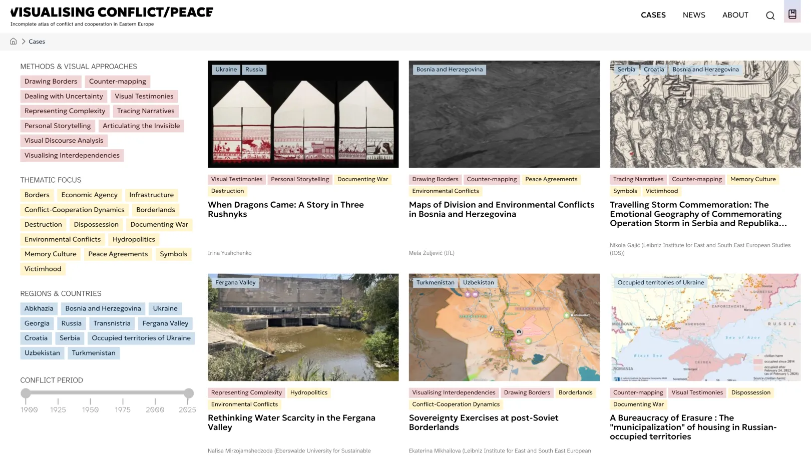
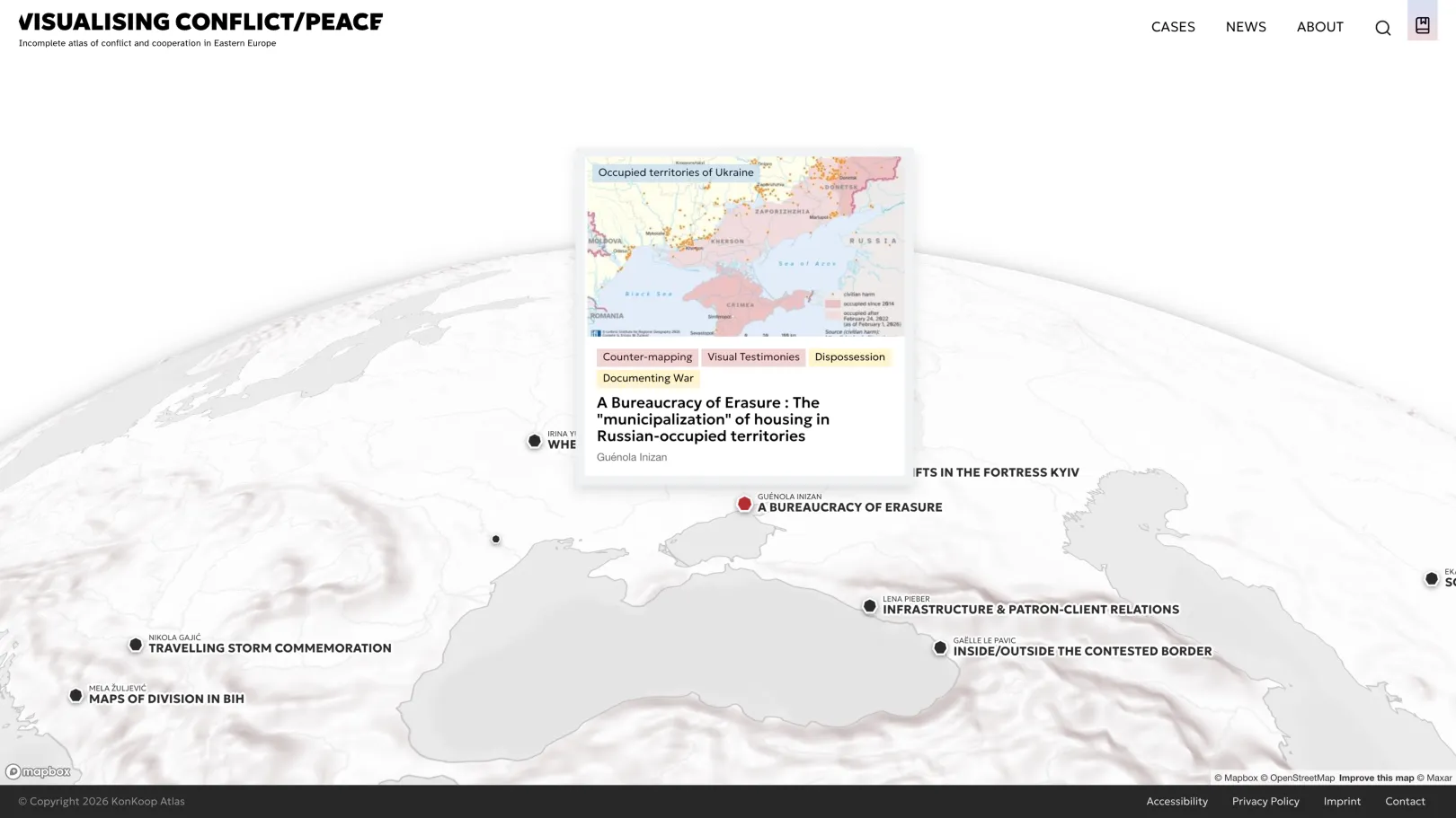
The result is a fully accessible Drupal 11 platform that launched with nine published cases spanning regions including Ukraine, Bosnia and Herzegovina, Georgia, Abkhazia, Transnistria, Serbia, Croatia, and the Fergana Valley. Cases are filterable across three independent taxonomies: Methods and Visual Approaches (such as counter-mapping, dealing with uncertainty, and visual testimonies), Thematic Focus (such as borders, hydropolitics, or memory culture), and Regions and Countries. The platform is designed as a living infrastructure: the editorial team can publish, revise, and expand cases continuously without requiring developer intervention, supported by automated workflows and in-context content editing.
Key features
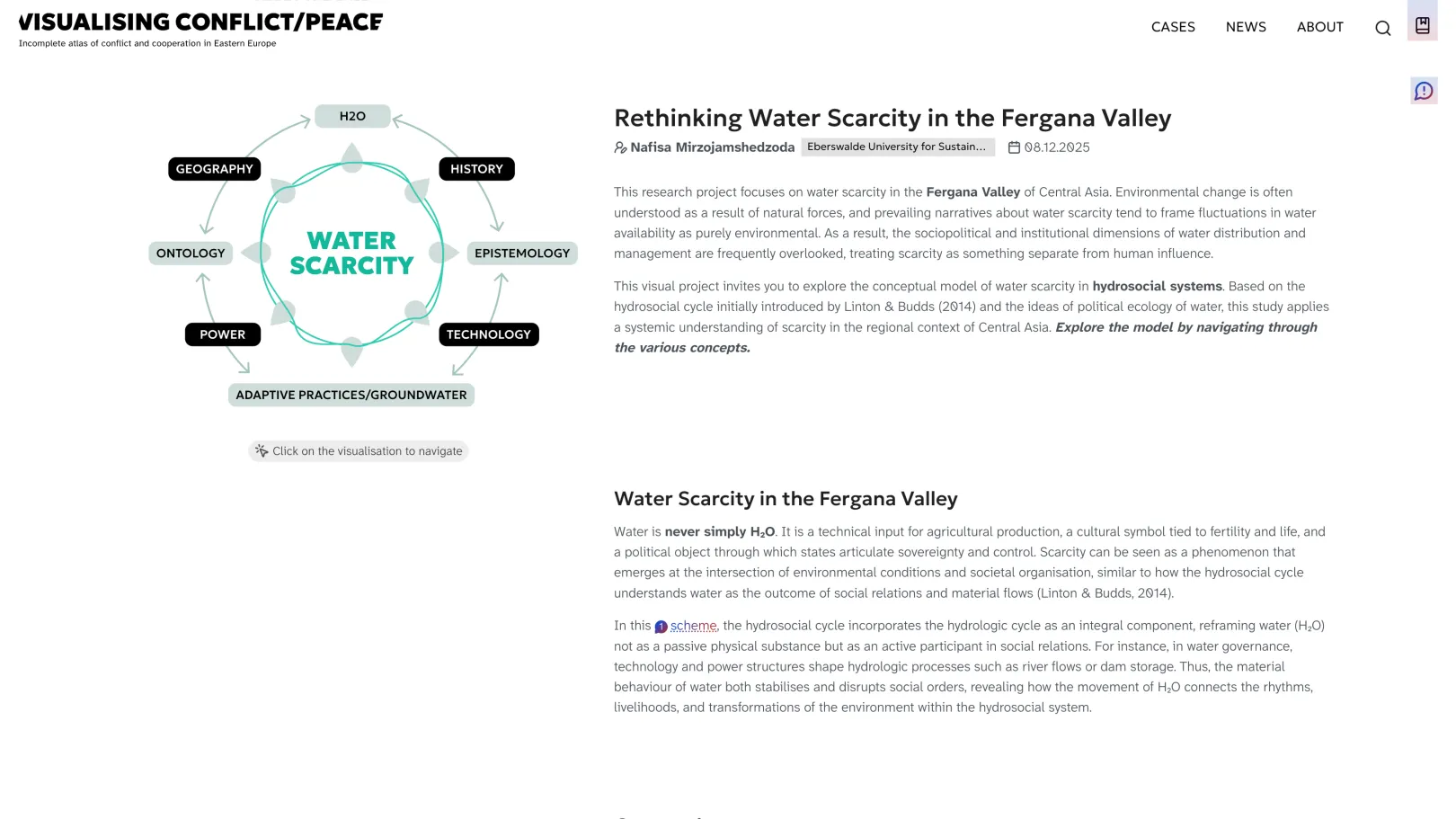
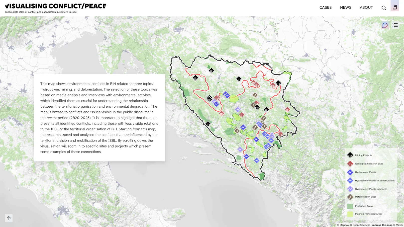
Each case integrates interactive geospatial visualizations — including Leaflet maps and Mapbox GL JS-powered 3D representations — directly alongside editorial text, making the platform as much a visual publication as a research repository. A signature feature is the reflexive layer built into every case: embedded hover highlights and a dedicated Reflection dialog reveal the assumptions, decisions, and perspectives behind each visualization, making the production process transparent rather than presenting maps as neutral facts. Scrollytelling effects powered by Scrollama and GSAP animations create an immersive reading experience suited to the complexity of the subject matter. The Library section complements the cases by offering methodological resources for researchers working with cartography and visual methods. The platform uses Matomo for privacy-compliant analytics, keeping user data within the research institution's own infrastructure.
What makes this project special
The atlas sits at an unusual intersection of academic research, critical cartography, and digital publishing — a combination that placed high demands on both the content architecture and the interface design. Rather than a conventional research website, it functions as an evolving collaborative knowledge infrastructure that grows with the research network. Its reflexive approach — surfacing the process behind visualizations rather than hiding it — required thoughtful UX decisions about how to layer information without creating cognitive overload.
Why Drupal was chosen
Drupal's strengths in structured content modeling and taxonomy management made it the right fit for a platform where every case carries multiple intersecting metadata dimensions — region, thematic focus, visual method, conflict period, and authorship. The ability to define and extend content types and taxonomies without rebuilding the system from scratch was essential for a project designed to evolve continuously as the research network grows.
Drupal's Layout Builder and Paragraphs ecosystem offered the editorial flexibility to accommodate the highly varied content formats the atlas requires, from text-heavy reflective essays to visualization-led case studies with embedded interactive maps. Its mature multilingual architecture, combined with translation management tooling, ensures the atlas can serve an international research audience. Drupal's robust accessibility foundation aligned with the IfL's requirements for an inclusive academic platform, and its active community ecosystem provided the specialized modules — from geospatial tooling to scrollytelling libraries — needed to realize the atlas's ambitious visualization goals.
Technical Specifications
Drupal version:
Flexible content architecture Paragraphs and Layout Builder together give editors the flexibility to build highly varied case layouts without developer involvement. Layout Builder's drag-and-drop interface, extended by Bootstrap Layout Builder for a consistent grid, allows the editorial team to compose each case individually – from text-heavy reflective essays to visualization-led studies with embedded interactive maps.
Maps and geospatial visualization Leaflet and Geofield provide the interactive mapping infrastructure at the heart of the atlas. Leaflet renders the case-specific interactive maps directly in the browser, while Geofield handles coordinate data storage. Geocoder supports address-to-coordinate conversion where needed.
Filtering and discovery Search API and Facets power the three-dimensional filtering interface across visual methods, thematic focus, and region. Views Ajax History ensures the browser's back button works correctly after Ajax filter interactions – a straightforward but important usability requirement for an exploratory research tool.
Multilingual content and translation TMGMT provides the translation management framework, while TMGMT DeepL integrates machine translation via DeepL directly into the editorial workflow. This combination allows the IfL team to efficiently manage translations across all cases without leaving the Drupal interface – essential for an international research platform publishing in multiple languages.
Automated editorial workflows ECA (Event-Condition-Action) drives the automated workflows referenced throughout the platform, handling tasks such as notifications on content updates and scheduled publishing logic. Its visual BPMN-based configuration allows the editorial team to understand and adjust workflows without developer support.
Reflexive content layer The CKEditor Tooltips module, extended by a custom project module, enables the embedded hover highlights that surface the reflexive commentary within each case. This was the key editorial feature distinguishing the atlas from a conventional research website.
Accessibility and content quality Editoria11y provides inline accessibility checking within the editorial interface, allowing the IfL team to catch and fix issues at the point of content creation rather than after publication.
Privacy-compliant analytics and cookie consent Matomo keeps all usage data within the IfL's own infrastructure, while the COOKiES module provides GDPR-compliant cookie consent management – both firm requirements for a publicly funded German research institution operating under strict data protection obligations.
Theme and frontend Bootstrap Barrio serves as the base theme, providing a solid Bootstrap 5 foundation that was extended with a custom sub-theme to meet the atlas's design requirements. Scrollytelling effects powered by Scrollama and GSAP animations create an immersive reading experience suited to the complexity of the subject matter.